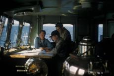
Scapa Flow, located in the Orkney Islands of Scotland, is the site of the scuttling of the High Seas Fleet of the Imperial German Navy in June 1919 at the end of World War I. While many of the wrecks were salvaged following the war, the remaining wrecks have become popular dive sites. In recent times, efforts to learn more about these wrecks through multibeam sonar surveys and 3D photogrammetry have taken place. Rosemary E. Lunn interviewed key figures involved in these developments to gain further insight.

Contributed by
“It takes years to get to know the German shipwrecks properly, to become familiar with these amazing shipwrecks, and to understand the sense of history that still pervades Scapa Flow both beneath and above the waves.”
Rod Macdonald, author of Dive Scapa Flow (Whittles Publishing)
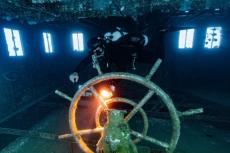
Shipwreck expert and explorer Rod Macdonald certainly has a point. But I would also argue that today’s visiting divers have an array of resources at their fingertips, which neither Rod nor I had when we first dived Scapa Flow, and these include very detailed three-dimensional images of the interned squadron.
In fact, these images have certainly changed my diving for the better. It had been a revelation to dive the German wrecks on my last trip there because I was getting significantly more out of my diving than on previous visits, simply because I had a better understanding of these massive ships (e.g., where to spot the brass bridge or find the signalling iris or lamp, turbine blades, etc).
When I mentioned this to expedition closed-circuit rebreather (CCR) diver Sally Cartwright, she agreed and echoed my first experience of the wrecks back in 1996. “When I first dived Scapa, I had not got a clue as to where I was going and what I was looking at. You could find yourself swimming along a steel wall the size of a 12-storey block of flats—and, whilst you were in awe of the size of the wrecks, you did not exactly get a lot out of the dive.”
In the main, it is down to the dive boat skippers utilising the superb work done by a bunch of ardent academics and talented dive professionals (i.e., technical diver Emily Turton’s presentations at EUROTEK.2018 were a masterclass in how to deliver a dive brief). The reference points are far more obvious, and they certainly help you orientate where you are, what you can expect to see in the vicinity, and in which direction you should swim.
We are fortunate that the researchers have now collected over two decades of data—recording baseline and monitoring information on this submerged heritage resource—and then generously shared the extent and condition of these historic assets with the recreational diving community.
Research projects
It all started in 1986, when the Archaeological Diving Unit (ADU) was formed at the University of St Andrews. At the time, two key members of the team—Martin Dean and Mark Lawrence—had 20 years of experience in geophysical surveying and side-scan sonar systems. Jump forward to 12 June 2001, and ADU’s dive support and survey vessel was used as a platform for a seven-day, fact-finding survey on the seven German warships. The highest quality images were taken, using state-of-the-art marine survey techniques based on multibeam sonar.
“We are getting some truly wonderful images of the wrecks in a far greater resolution than anything we have seen before. We can see the ships lying on their sides, and how much damage has been caused over the years [because of and as a result of the salvage].”
Mark Lawrence, Archaeological Diving Unit at the University of St Andrews
This project revealed the potential of multibeam sonar as an effective method for accurately and rapidly surveying shipwrecks without involving dive personnel.
Two years later, in 2003, a new diver visited Scapa Flow. His name was Chris Rowland, and he was an academic researcher from the University of Dundee in the United Kingdom, specialising in 3D animation, design and fine art.
“I fell in love with Scapa Flow, and I have been up here at least once a year since then.”
Chris Rowland, University of Dundee
By 2006, Rowland was a professor and the director of the 3D Visualisation Research Laboratory at the University of Dundee. He was also back in Scapa Flow, this time at the behest of the Ministry of Defence to conduct a multibeam sonar survey of the WWI German Fleet, working alongside the St Andrews’ academics.
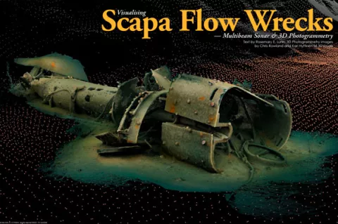
This would prove to be a unique, powerful collaboration. When you amalgamate Dean and Lawrence’s survey data collection methods with Rowland’s novel visualisation skills, the result is WreckSight. It is a pioneering technique that captures and shows high-resolution, 3D multibeam data. In a nutshell, the software provides you with very detailed still and three-dimensional moving images of these historic and environmentally significant shipwrecks.
This was an exciting time for the academics—the improved results turned heads in the private sector. The oil, gas and wind-farm industries were hungry for better information, because the team’s accurate surveys assisted with critical decision-making during salvage, wreck removal and environmental clean-up operations. As a result, the academics were commissioned to work on some interesting projects, and these included the Costa Concordia (i.e., visualisation of the wreck to aid the recovery of the ship) and Deepwater Horizon (i.e., visualisation to help investigate the cause of the disaster).
“If you can see it, you can understand it, and you can plan conservation for the future.”
Chris Rowland, University of Dundee
Imaging advancements
Imaging technology continues to change, and one of the more interesting developments on the wreck-survey front has been 3D photogrammetry (where one extracts a three-dimensional image from two-dimensional data). The level of detail that you get via photogrammetry is far beyond the current capability of multibeam sonar.
I asked photogrammetry educator John Kendall to describe the process in plain English. He responded: “Take lots of photos that overlap, then use a clever piece of software to turn them into a digital 3D model. Prepare to swear lots during the process, and you will warm up a small town with the heat generated from your laptop, because this takes a massive amount of computing power.”
The photographic process requires precise planning and execution so that each high-resolution image systematically overlaps another in the correct sequence. You also need a lot of light, several thousand lumens worth, to provide enough illumination to capture the images in temperate water.
Thirdly, if you are working over a large distance, it is possible you will get data distortion; therefore, you have to mark key features with rulers. This works very nicely until you get friendly seals discovering a new toy and moving the rulers. The results are worth all the hard work though, because the amount of detail you get is extraordinary.
Photogrammetry survey
In 2016, CCR expedition diver Professor Kari Hyttinen of Finland was invited to join Rowland to become part of the HMS Hampshire survey team because of his expertise in photogrammetry. As a result, the two academics are pushing the technology again, combining multibeam and 3D photogrammetry with extraordinary results. It is one heck of a task though because you are looking at something like 23 million data points to create the total image.
I was fortunate enough to be shown the spotting top on the Kronprinz Wilhelm during my #Scapa100 trip during the centenary anniversary event at Scapa Flow in June 2019 (please see: xray-mag.com/content/scapa-100-centenary-anniversary-event). It blew me away that one could see every nook, cranny, crevice and sea urchin.
I had just dived the wreck, “standing” inside it as though the ship still sailed, to get some sense of scale. I was not tall enough to look over the top edge of the spotting top. I could just about peek out of the observational slit. And there it was, right in front of my eyes on a computer screen—the observational slit on the rendered image.
It made me instantly think of the work done by marine artist Ken Marschall. He has a much-deserved reputation for rivet counting and then creating an exact painting of a vessel. The spotting top image was easily on par with Marschall’s work.
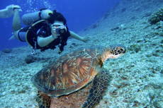
Three-dimensional photogrammetry appears to be the perfect solution, but when I spoke to Hyttinen about his work, I learnt that this is not the case. One cannot use it to capture everything. If there is an object that moves, such as a flag flying from a wreck, the software algorithm just cannot cope. It either messes up the image or ignores the data. The best way to capture a dynamic image is by photography; hence, the team has also been working with two expedition CCR photographers, Marjo Tynkkinen and Kieran Hatton.
Summary
There is still much to learn about the iconic wrecks of Scapa Flow. Now, after data on baseline and monitoring information has been meticulously and systematically collected over the last 20 years, the extent and condition of the Scapa Flow wrecks has been generously shared with the recreational diving community. The latest technical developments in multibeam sonar survey and 3D photogrammetry are leading the way to better understanding and insights of these historic assets in this submerged heritage. For more information, see the video of Chris Rowland's presentation on photogrammetry at: youtube.com


")