There is no doubt that Yucatán in Mexico is a fascinating region. Not only for its culture, its unique nature and wildlife or the archaeological sites of the ancient Maya, but for the simple fact that it is a cave diver’s paradise. Pierre Constant has the story.
Contributed by
It was my fifth time visiting Yucatán in the last five years. Back in 2017, I had taken part in a TDI Sidemount Cave Course in Playa del Carmen. In 2018, I dived the cenotes around Merida and was back again the following year for more. In 2020, my cave training was pushed one step further with a Stage Cave Course in Playa and with a DPV Cave Course (Diver Propulsion Vehicle) in Tulum—even more exciting, but nonetheless challenging. At this level, you cannot use an underwater camera anymore, since you need both hands to deal with the equipment.
As a new diver to the cenote world, you cannot pretend that you have done Yucatán after a single trip! A normal Open Water diver would only be allowed “cavern dives” in a cenote, meaning to say, dives in which daylight is in sight at any given point in the dive. Anything in an overhead environment requires specific cave training, followed by Advance Cave training, well before the Sidemount Cave level and so on…
Needless to say, most divers experiencing cenotes for the first time would only enjoy limited access. Furthermore, they would only get to know the most classic sites, which everybody dives—the tourist side of it, essentially.
With thousands of cenotes to choose from on the Yucatán Peninsula, it is reasonable to assume that it would take a lifetime to explore it all, in the best-case scenario—assuming you have the level, the experience and the guts to do so, that is! Only the most dedicated, hard-core, resident cave divers keep on discovering new cenotes every now and then, or push farther into the unknown in existing cave systems. Ponder this for a minute: The longest underwater cave system known today connects 187 cenotes together, with a mind-blowing 365km in length.
Geology
Who has not heard of the meteorite that struck the earth, just northwest of the Yucatán Peninsula, 66 million years ago during the Cretaceous-Paleogene boundary? The result of the impact of an asteroid, the Chicxulub Crater is located northwest of Merida, carved well into the continental crust.
Measuring 300km in width and 20km in depth, it was responsible for the second mass extinction on the planet (that of non-avian dinosaurs), as well as the demise of 75 percent of all plant and animal species. The whole world was affected at the time. This marked the beginning of the secondary era (Mesozoic).
What most people do not know, however, is that 170 million years ago, Yucatán was not yet part of Mexico. Before the breakup of the supercontinent Gondwana—comprising, among others, North America, South America and Africa—Yucatán was temporarily attached to the northern side of South America (Venezuela). As the proto-Atlantic and the Gulf of Mexico began to form, Yucatán broke away from the continent and became an isolated plate 140 million years ago. Rotating counterclockwise and drifting west for the next 50 million years, Yucatán collided with Mexico. A fracture zone emerged on the east of the peninsula, and the Yucatán basin was formed.
Moving westward, the Caribbean Plate came into being from an Atlantic hotspot that faded in time. The oceanic crust of the South American Plate is in subduction under the Caribbean Plate, underlying Central America and the Caribbean Sea. The borders of the Caribbean Plate are regions of intense volcanic activity.
The Yucatán plateau is made of 144-million-year-old Cretaceous limestone. No surface rivers exist. The subsoil is like a sponge, through which water seeps. Although it seems obvious to me that the meteoritic impact created a vast spiderweb of fractures underground, over the millions of years that followed, the rains dissolved the limestone further—creating water streams below the surface—with the occurrence of sinkholes. Most surprisingly, the longest underground rivers in the world are found in the coastal region of Quintana Roo, east of Yucatán. These impressive underground rivers are classified as “systems.”
Prehistory
Ice ages affected the Yucatán Peninsula between 150,000 and 20,000 years ago. The last ice age saw the arrival of people from Asia, via a land bridge, through the Bering Strait. Due to extremely cold conditions, people lived underground. The sea level was 65m below actual levels back then.
Prehistoric animals also made their home in those caves, including bears, giant ground sloth (Nothrotheriops shastensis) and the saber-tooth tiger (Smilodon fatalis). Above ground roamed the mammoth (Mammuthus columbi), mastodon or gomphothere (Cuvieronius tropicus), glyptodont or giant tattoo (Glyptotherium floridanum), which was 9ft long. So did llamas, camels and horses—the latter two made their way into Asia.
At the end of the last ice age, about 8,000 years ago, sea levels rose. Most of the caves were flooded by seawater. Fresh water from rains naturally formed a distinct layer on top. In-between is a blurred layer, known as a “halocline,” where salt and freshwater mix.
Cenotes
Much later in time, caves played an important role in Mayan cosmogony. The word cenote originates from the Mayan word dzonot, meaning something deep, a chasm or cavern, filled with water. These cenotes symbolise the entrances to Xibalba, the underworld or abode of the dead, but also a fertile place where life originates. It is the symbolic path between the earthly world and the “infraworld.”
Vases and potteries have been found in these sinkholes, but also offerings such as human sacrifices of young girls. They sometimes served as burial grounds for older people or dignitaries. Nowadays, Mayan people regard the cenotes with respect, as places for aluxe, or cave spirits.
On to Playa del Carmen
The Air France flight to Cancun landed at night. After I got the car hire sorted out, I reached the hotel one hour later, slowed by some rain on the highway. Once in Playa del Carmen, I finally made it to bed well after midnight.
A transition day was compulsory, to prepare my dive equipment and underwater camera. I was to meet Max, my cave diving guide, on my second day here. It was by sheer coincidence that we had met four years earlier, while on a Merida cave diving trip together.
In very professional form, Max started with a thorough revision of my cave diving gear, complaining about a thing or two, like the absence of a long hose on my second regulator, a line cutter, spools, etc. The truth was, I had not been cave diving for two years, and a refresher was needed.
I felt a bit of tension at the thought of being in an overhead environment again. So, I needed to be fully focused to undertake the task. When not practising regularly, one forgets things. In this type of activity, there is no room for error. At any rate, I had already done 25 cenotes/caves in past years and was now looking for something new, exciting, and if possible, “special.”
Ruta de los Cenotes
Our initial drive took us north to Puerto Morelos, from where we turned west onto the “Ruta de los Cenotes” (Cenote Route). Rather dry, the Yucatán jungle is 10 to 15m tall maximum, home to amazing birds and fascinating animals such as jaguar and puma. “I have been placing infrared cameras in remote spots of the forest and managed to get shots of the creatures,” said Max proudly.
Cenote El Zapote. Our plan was to dive El Zapote, a dome-shaped cenote in the dense jungle. The hourglass-shaped sinkhole is rather dark, once one is underwater. There is a poisonous layer of hydrogen sulphide at a depth of 30 to 35m. The trunk of a zapote tree emerges from it like a ghost. “Deep down, the skeleton of a subadult giant ground sloth (Xibalbaonyx oviceps) was found by researchers in 2017,” said Max.
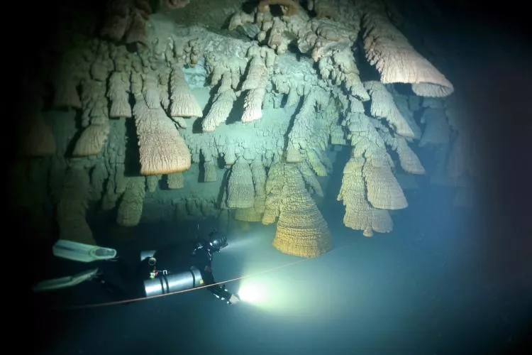
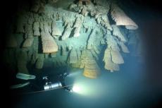
What makes Zapote so unique are the so-called “Hell’s Bells” (or inverted mushroom-shaped stalactites) hanging from the walls. The anomaly here is that these formations are made in water, resulting from a biogeochemical mechanism, whereas bacteria trapped in the hydrogen sulphide layer create the bells.
Known as “extremophiles,” these tiny creatures thrive in extreme environments, processing sulphur, raising the pH of the water, and causing unique formations to develop above the halocline. The bells are therefore alive on the outside, and sulphur-powered organisms are contributing to the calcium build-up.
Forming only near the layer at a depth of 90 to 115ft, the bells require a low-light environment. In 2020, a researcher’s theory projected that the bell-shaped stalactites were formed that way due to carbon dioxide bubbles rising from the deep, being trapped against the almost horizontal ceiling. Some of these funny mushrooms can be 1 to 2m in length, and 80cm wide.
The micro-organisms consume carbon dioxide, facilitating the deposit of calcite by metabolising nitrogen from alkaline to acidic compounds, under the influence of sulphur and nitrogen redox processes, thus forming biofilms on the surface of the bells, by producing polymers that concentrate calcium.
German researcher Wolfgang Stinnesbeck of the University of Heidelberg investigated the bells, as they are something of a natural wonder. Neighbouring sinkholes also contain similar structures. The zapote tree, at the bottom at 54m, turned out to be 4,500 years old and displayed “baby bells” as well! Radiometric dating of some of the bell specimens indicated that they had grown during the middle and late Holocene, starting over 5,200 years ago.
Cenote Maravilla. For our second dive, Cenote Maravilla was just nearby. It was a circular sinkhole, partly blown up by the owner, with a steep wooden stairway climbing down into it.
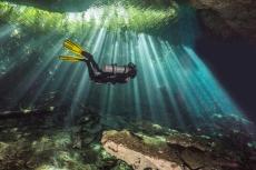
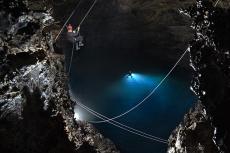
Once underwater, one realised the conspicuous dome shape. No formations worth mentioning here, but there was great visibility and a magnificent shaft of light that pierced down into the deep, in the early afternoon. In addition to the ambiance that it offered for underwater photography, it was a training site for free divers. The water temperature was 25°C.
Sac Actun cave system
Over the next couple of days, we headed south. Our dive trip took us near Dos Ojos, to the Sistema Sac Actun, which was found to be the longest underwater cave system in the world in 2018, connecting 187 cenotes!
In March 2008, three members of the “Proyecto Espeleológico de Tulum” (Tulum Speleological Project) explored the Hoyo Negro pit and found the remains of a mastodon, measuring 60m. In addition,at 43m, the skull and bones of a teenage Mayan female, now referred to as “Naia,” a Paleo-American, was found and dated to 12,000 to 13,000 years old.
Cenote Tak Be Ha. At Cenote Tak Be Ha (Secret Water), our tanks were brought by rope through a chimney hole in the ceiling, down to the water level. I assisted with receiving the tanks. A rather steep stone stairway allowed us to walk down into a large, wide chamber, with lots of decorations and artificial lights.
Cenote Concha. Farther away in the forest, an 8km potholed dirt road led to the site of Concha—a half-collapsed sinkhole with a huge alamo tree, extending its roots like the tentacles of a crawling octopus. The atmosphere of the jungle was overwhelming. Entry to the water was very shallow, over white sand. Outside the cave were tall leafy trees, and beautiful “motmot” birds flew by.
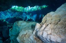
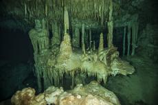
Sneaking through a narrow gateway in the limestone, we immediately plummeted down to a depth of 14m for the rest of the dive. Visibility was gin-clear. At the first T-junction of the guide line, we veered left, soon to meander through various chambers with columns, stalagmites, stalactites and helictites hanging from the roof like darts.
After 30 minutes, my gauges displayed 140 bars, and Max pointed out an overhang above the cave floor. To my surprise, I discovered a full skeleton of a giant ground sloth (Xibalba oviceps) from the last ice age, over 10,000 years of age. It rested precisely in the same position where it died. On the way back, Max drew me aside, into a small chamber. A little signboard with the number 285 on it marked the bones of a small gomphothere (Cuvieronius tropicus), an extinct mastodon with straight-forward tusks. Impressive.
Following the narrow jungle trail back to the car, with a tank on my shoulder, I noticed with awe a tiny snake coiled neatly on top of a white rock. Of course, I rushed back to take a photo. “Be very careful, this is a nauyaca!” warned a Mexican cave diver, who happened to be passing by. “A friend of mine got bitten and remained in intensive care at the hospital for four days.”
The cuatro narices, or ultimate pit viper (Bothrops asper), is one of the most poisonous snakes of Yucatán. Also known as fer-de-lance, it can spit venom at a distance of two metres. I was no more than 50cm away when I took the shot. Soon after, Max found a hairy Yucatán tarantula (Brachypelma epicureanum) on the forest floor. Black with a reddish abdomen, it swiftly hid in its hole.
Cenote Koi and Cenote Xuxi. On my fourth day of cave diving, Max took me to one of his favourite sites, located 20km from Tulum and 8km inland. It proved to be a total immersion with nature.
An inquisitive tarantula came to welcome us at the car park, as we prepared our gear and tanks. On the 50m stroll to Cenote Koi, a 60cm long southern Yucatán variable coral snake (Micrurus apiatus) slithered along the forest floor. It was dark red in colour and had black bands outlined with narrow yellow bands. It was a gorgeous creature—rather shy, but poisonous.
A rusty iron stairway spiralled down into the narrow opening of the cenote, straight to the water table. A few cement blocks made it convenient to lay down the tanks in shallow water. The cave had a wide dome, with a low ceiling, ornately decorated with stalactites, plus a few bats. The cave floor was composed of black and volatile bat guano. The walls were white limestone.
At a depth of 10 to 14m, Max led me underwater to Cenote Xuxi. “I’ll show you something special!” he said. There, I marvelled at an incredible sight. During the rainy season, soil and leaves caused a lot of tannin to seep down into the water subsurface. This translated into a breath-taking variation of red, orange, yellow and green hues in the water column—like a vision from the film Apocalypse Now.
We pushed farther into various chambers, heading the other way around.
After a picnic of tacos, we were back to Koi for a consecutive dive. This time, we jumped left and T-right, straight to an indistinct pile of elephant bones, after a 30-minute swim. Little white cones from the Instituto Nacional de Anthropologia y Historia (INAH, the National Institute of Anthropology and History) had been placed as indicators for scientific investigation.
Cenote Uku Cuzam. South of Tulum, just before one reaches Muyil, is Cenote Uku Cuzam or Canto de las Golondrinas (Song of the Swallows). It is also called “Xulo,” after the local Mayan owner. Originally explored by Alvaro Roldan in 2013, it is now connected to the Systema Caterpillar, just downstream from it. “A five-star cenote!” exclaimed Max with excitement.
An old man named Emilio was the caretaker of the place, with his two dogs. Once we paid the 300 MXN (pesos) entry fee, we proceeded down a flight of steps, which led underground. A low-lying cenote, the water table was in the darkness, and I had to turn on the lamp on my helmet to get equipped with the tanks.
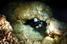
Very quicky, the guide line plunged down to a depth of 10m, into highly ornate chambers, with awesome pillars, showers of stalactites, stalagmites in the shape of fingers or chandeliers, walls of draperies and helictites. But it was an enchantment that would be short-lived! Max suddenly made a jump to the right, into a corridor of restrictions under a low ceiling.
Turning around was unthinkable. With its extended strobe arms, I needed to turn my camera sideways, in order to proceed forward. It was rather uncomfortable. Eventually, we caught up with the main line running in a side tunnel. Another jump and it was back to base from here. All in all, it was a 56-minute dive. The strobes stopped working, functioning below satisfaction, and I suspected the batteries were low. I would leave the camera behind for the next dive.
This was a wise decision, since my dive guide made a jump to the left, after a third set of double arrows and led us through restrictions and very narrow passages under the cave’s ceiling, snaking sideways non-stop! He even signalled me to stop in key moments, so he could take a video of me in action, with his GoPro camera.
After 67 minutes, apparently happy with my performance and optimal buoyancy, Max shook my hand positively before exiting the cave. Sitting peacefully in front of his wooden shack, Emilio was waiting for us with a Caguama, a one-litre bottle of beer, and the dogs resting flat on the ground beside him. A couple of keel-billed toucans (Ramphastos sulfuratus) flew overhead, and landed on a branch to have a peek at us, but took off as soon as I grabbed my camera.
Tulum
Cenote Regina. Based in Tulum for the next three nights, my last day of diving would be with dive guide Elliot. The dive site was called Cenote Regina. Originally explored in 2004 by Robbie Schmittner, it was now connected to Sistema Ox Bel Ha (via Mayan Blue). It was not well-known to divers, except for the lucky ones!
Here, there was a large pool of water with a wooden deck, surrounded by palm trees. The entrance hole was murky and started with a restriction. It opened up into a rather dark cave with a wide tunnel. The plan was to take a T-left, then another T-left, until we plunged deep into a canyon at a depth of 25m.
All of a sudden, it lit up as if by magic, in the so-called “Alexis Passage,” an underground riverbed that was white and light blue in colour. We then met a halocline, where the saltwater below met the fresh water above it. For 30 seconds, it was all a blur. A mesmerising environment indeed, but it was already time for us to turn around.
For the next dive, the plan of action was to take a T-right, then a T-left and T-right. Once again, we dropped into a deep saltwater passage below 18m. As I gazed at Elliot disappearing into the haze of the halocline, my right ear became terribly painful under the pressure. I realised at once that I could not go deeper without some serious trouble. This could turn into a nightmare in seconds. I waved my light frantically until Elliot understood my signal of calling off the dive. Better safe than sorry.
Tren Maya
In September 2018, Mexican president-elect Andrés Manuel López Obrador announced project “Tren Maya” (Maya Train). Slated for construction around the Yucatán Peninsula, it would be 1,525km long. Owned by the Mexican Armed Forces, it would connect the cities of Palenque, Escárcega, Merida, Cancun, Tulum, Bacalar and loop back to Escárcega. A referendum, conducted in the various cities, showed that 92 percent of the people were in favour of the project, because of the tourism development and other benefits to the population.
Construction started in June 2020 and is expected to be completed by 2024. Funding would be primarily from a tourism tax levied in the region. In October 2020, the cost was estimated at 321 billion MXN, about 16 billion US dollars. Twenty-five percent of the project had been completed by February 2022.
However, environmental and indigenous rights activists objected to the construction of new railway tracks through the jungle. Environmental concerns raised awareness of a projected disaster for nature.
In January 2021, crews had uncovered more than 8,000 ancient artefacts and structures during excavation. In Quintana Roo, there were protests against the construction work that involved the cutting down of jungle areas without first conducting the required environmental studies.
To the cave diving community, this whole project was outrageous, because it would trigger the collapse of many cenotes and caves along the way. Sadly, this has already happened. In Quintana Roo, 1,800km of caves and underground rivers run through thousands of cenotes, which would be violated by the Maya Train project. In fact, at least a hundred cenotes have already been affected.
Infrared cameras have shown that wild animals (like the jaguar, puma, spider monkey, ocelot, aguti and motmot (toh) birds, among others) use the cenotes for drinking water. The Maya Aquifer is at high risk of pollution from freight trains and other factors.
President Lopez Obrador had designated the Mexican Army as the contractor of Section 5 of the railroad track (which connects Cancun with Tulum) and the beneficiary of the project. This move was considered controversial as the Tren Maya project had never complied with environmental legislation. However, the president has rejected all concerns raised and forged ahead with the project, aiming to have it completed before the end of his term.
[ed. – In August 2022, construction of Section 5 was temporarily suspended by a federal judge, on the grounds that an environmental impact statement (EIS) had not been completed or approved. Since then, the same judge has lifted part of the suspension, after the federal Environment Ministry approved the EIS for Section 5 North. However, as of 29 September 2022, the suspension order halting the construction of the controversial Playa del Carmen-Tulum section of the railway, which is the southern stretch of Section 5, is still in place. (Source: Mexico News Daily)]
On my way to various cenotes, I have seen these wide highways of destruction through the Yucatán jungle. I must say that this vector of deforestation looks horrifying, and I am deeply saddened by the impact on nature and wildlife in the area. The government has only shown the positive side of the Tren Maya project, economically and as a tourism development tool. But all the negative aspects of the project have been carefully and deliberately hidden from the public.
The original plans called for electric locomotives on the trains, but the government announced a switch to diesel to reduce costs. In August 2020, it confirmed that half of the Merida-Cancun-Chetumal route would still be electric. In November 2021, the Interior Department exempted Tren Maya and other infrastructure projects from environmental review. As usual, so-called “progress” cannot be stopped, for ultimately, it is all for the sake of making money.
Topside excursions
Besides the limitless opportunities of cave diving—unless you are a beachcomber or a party animal—there is still much to do around Yucatán. Whether it is visiting old colonial towns, ancient Mayan archaeological sites, or nature reserves—the choice is yours.
Having done a number of land tours to these sites in past years, I opted this time for a road trip to the southwestern area of the peninsula, all the way to Chiapas. Out of Tulum, Palenque can be easily reached in one day, with a hire car. I skipped a visit to the famous archaeological site of Palenque; it is all commercial these days, with not much to see, and the fine cultural museum was closed for maintenance!
Instead, I made it my goal to visit two remarkable sets of ancient Mayan ruins to the southeast, on the border with Guatemala: Bonampak, for its astounding murals of the Templo de las Pinturas; and the remote Yaxchilan, in the lush Lacandon jungle, which can only be reached by river boat. Here, howler monkeys were omnipresent, vocalising loudly and unchallenged during the whole duration of my visit. In these parts, Mayan communities were authentic, and pristine Nature was queen, at last. ■
For more information, contact Didier at Phocea Mexico dive centre in Playa del Carmen, Quintana Roo, Mexico. Email info@myphocea.com or visit: myphocea.com.

