Who could imagine for a minute that Namibia is a diving destination?
Nobody. Despite its 2,000km of coastline, this is the mere truth. The marine temperatures are about 13°C on average, with an almost nil visibility resulting from stirred up waters and omnipresent sand. There is nevertheless a light of hope at the end of the tunnel. Some 30 years ago, caves and sinkholes were discovered, a peculiar reminder of the ‘cenotes’ in Mexico.

Contributed by
In the old days of the German colony (1890-1915), the farmers of the north-east would draw water from these sinkholes, with electric pumps, for their cattle and in order to irrigate their farms. A hundred thousand years ago, San or Bushmen knew about their existence, too, for they gave names to these natural pits. Somehow, these inspired fear. The belief was that, whoever fell in would not come out alive!
Originating in Antarctica, and born roughly five million years ago, the cold Benguella current flows from south to north along the Atlantic coast, creating a coastal desert. For sure, these waters are rich in fish and marine life, due to the upwelling of the Benguella current. Twenty species are currently harvested—hake, monkfish, sole, kingklip, snoek, but also horse mackerel (Scomber japonicus), pilchards, anchovies, skipjack tuna, albacora, spadefish and pelagic sharks. Aquaculture is prolific, with a substantial production of oysters in Walvis Bay, Swakopmund and Luderitz (six million per year), abalone farms, mussels and agar agar in Luderitz, not to mention rock lobsters and deep water crabs. All in all, conditions that favour fishing, but which are resolutely a ‘no no’ for divers.
Geology
Once upon a time, the region was called Süd-West Afrika by the Germans. The actual territory of Namibia is a very old land, geologically speaking. Before the creation of Gondwanaland, some 540 million years ago, Earth was a huge ocean with some isolated ‘cratons’, which are commonly referred to as the original crust of the planet. Two thousand five hundred million years ago, southern Africa was made of two cratons: the Congo craton in the north and the Kalahari craton in the south, both separated by a southwest-northeast extension of the ocean, known as Damara Sea.
Limestone like deposits were then generated. The Kalahari craton then collided with the Congo craton, with the subsequent subduction of the former under the latter.
Three hundred million years ago, Namibia was located near the South Pole and affected by tremendous glaciations. These ended 280 million years ago, when this part of the continent broke off from Antarctica.
The calcareous reef thus created in the Damara Sea 750 million years ago, were not made of coral—since it did not exist yet—but were secreted by cyanobacteria, better known as stromatolithes. These encrusting algae are the oldest living forms on the planet (3,500 million years). Deposited over a period of 100 million years, these sediments formed layers of dolomite 5,000 metres thick. Mind blowing, right?
The intensive erosion that followed over the next 500 million years and during the humid phases of the Cretaceous and Tertiary, brought about the dissolution of the carbonates, a process known as karstification. Lime or dolomite, are eroded by an acid carbonic solution, related to rainfall.
The magic triangle
The “magic triangle” is found in the region of the Otavi Mountains, located between Tsumeb, Grootfontein and Otavi. At least 83 caves, chasms or sinkholes have been listed since 1974. A good number of those have been surveyed by Germans, South African, and Swiss speleologists since 1967 and even earlier.
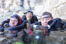
Upon the occasion of one of my numerous trips to Namibia since 1992—being myself a cave diver since 2003—I decided eventually to find out about this. Accompanied by my Japanese client and friend Tetsuaki Masuda, we showed up at Aigamas farm one morning on 1 April 2013.
Cordially welcomed by Axel Bauer, a tall German farmer who could be straight out of the movie Out of Africa. We also met Chris and Steff, the fine team of technical divers from Namibia who will be responsible for logistics and security during our diving explorations.
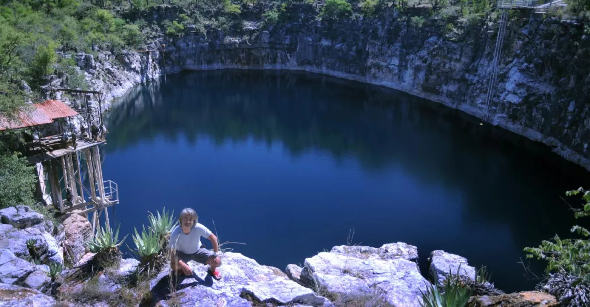
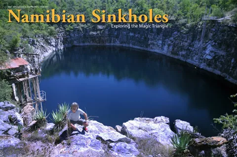
Aigamas sinkhole
Aigamas is a local name, which in Herero language means big water. We drove up a mountain ridge of the farm with the 4x4 to get to it. The proper access did not look like much. The cave had a tent-like shape, pointed like a teepee, along a south-north fracture in dolomite limestone.
“It will be a 120 metres progression in the dark,” said Axel referring to a sketched map before we ventured inside. We all had to sign a liability release as well.
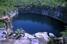
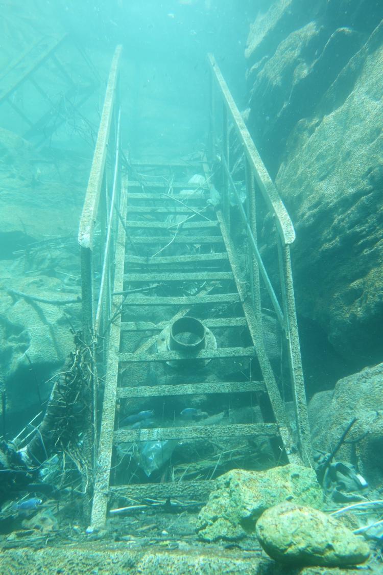
The gradual slope was negotiated partly with a metallic stairway, then we made our way with some ropes on slippery boulders covered with debris, until we reached the platform. An iron grid overlooked the pool of water about 18 metres long. From here an iron ladder plunged 5m below, down to the water level.
“The exploration and a survey attempt was done by a Swiss-Italian team in 2011-12,” said Axel.
Lead by Gerald Favre of the Swiss Société Spéléologique Genevoise, the survey map was done by Alessio Fileccia from Italy. The maximum depth of the dive was recorded at 93 metres, but the bottom was not reached. The fact is that Aigamas is a very narrow fracture that plummets into a void.
April fish
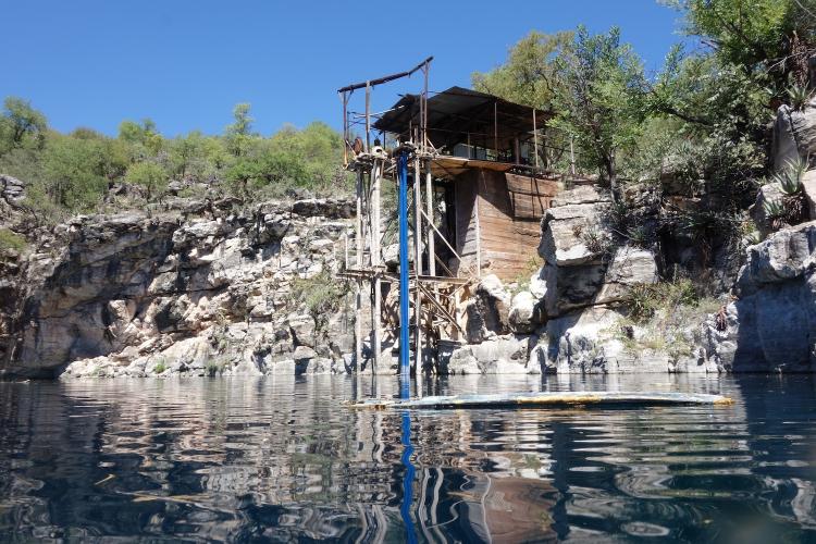
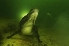
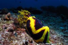
My quest today was stimulated by an encounter with the April fish (from the French saying, “Un poisson d’Avril”) and that one is no joke! Fortunately we found it, for it is endemic to the site.
Clarias cavernicola, or giant cave catfish, is a very unique species. Mostly found at the surface of the water, where it feeds on the floating guano of bats, which falls from the roof of the cave. A priori blind, the fish is about 16 to 25cm long, sulphur yellow in colour, with two pin-like turquoise blue eyes. The rounded head has the shape of a bony helmet, pointed like an arrow behind the nape.
Eight conspicuous barbels are found around the mouth, which enable the cave catfish to detect its food. It possesses a long dorsal fin, two small pectoral fins, two pelvic fins and a long anal fin that ends towards the tail, which is short and straight. Clear chevron markings are visible along the sides. The body is compressed, fusiform and eel-like. These characteristics are enhanced by the undulating movement of the catfish. Some specimens show an atrophy of the eyes, which become globulous and obviously useless.
The ancestor of Clarias cavernicola is most certainly from the Kunene or Okavango River further north, from the time when these rivers were flowing into the Etosha Pan (3 million years ago). Etosha was once a huge lake part of the Ovambo basin.
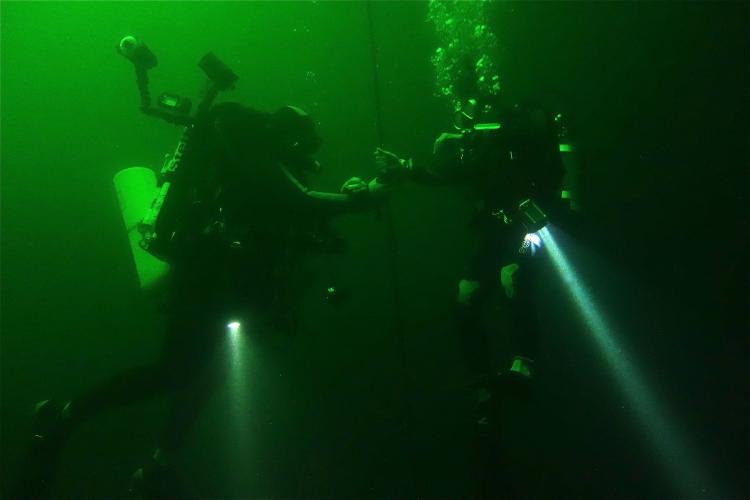
I sank down to a depth of 37 metres, in a crack that is hardly two metres wide. The water temperature was exquisite at 25°C. A number of bat corpses were found lying on the edges underwater, complete and apparently undisturbed by the catfish. It is said that the fish has also a cannibalistic behavior on the young individuals. I exited Aigamas as a true cave man, covered in bat guano, to the delight of Steff who recorded the scene on his Go-Pro, as soon as I dropped the scuba tank.
Otjikoto sinkhole
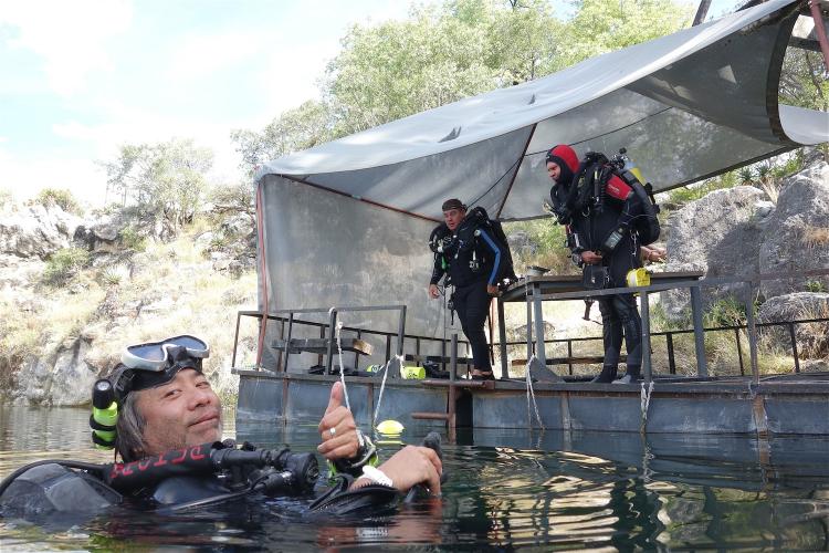
Some 20 minutes north of Tsumeb, is Otjikoto Lake—an historical site that depends on the National Heritage Council of Namibia, a government body which governs research and archeology. A diving permit is compulsory. Delivered by the Namibia Underwater Federation, it is submitted for approval by the National Heritage Council, which controls all dive activities at Otjikoto. After Chris presented our permits to the authorities and we each paid the N$25 entry fee, we were welcome to proceed.
Originating from the Otjiherero language, the name Otjikoto means, a place too deep for cattle to drink. The San called the site Gaisis, or very ugly, as it inspired fear in the bushmen.
Before the arrival of the first Europeans, the site was a trading post. Later on, the surrounding hills were guarded by armed men to prevent any exploitation of the copper ore, which was plentiful there.
Otjikoto was officially discovered in May 1851 by Charles Anderson and Francis Galton.
For the geologists, Otjikoto is a perfectly circular dolomitic sinkhole in the karst of the Damara Belt. Shaped like a calabash, the lake has a diametre of 102m and a surface of 7,075 sq m. As the depth at the centre has been estimated at 71m, the maximum depth on the sides went well beyond 145m, and to this day remains unknown.
“Come on, I’ll show you the dive plan!” shouted Chris with excitement, as we neared the edge of the cliff for a panoramic view. “The idea for the first dive is The Reef, an acclimatization dive at 40m on the southern part of the sinkhole.”
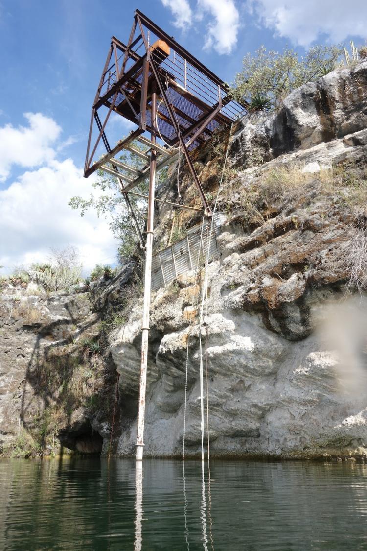
Carrying the 15-liter steel tank, we accessed the water by a small metallic stairway. “The level of the lake has never been so high, since the heavy rainfall of last year,” commented Steff. The level would normally have come up ten metres or so.
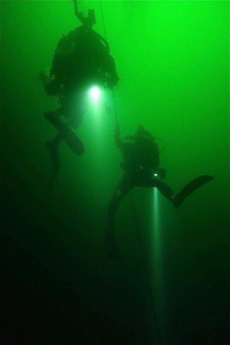
Finning on our backs, we crossed the lake from north to south. Hovering above The Reef, we eased ourselves down with the help of a chain anchored to the bottom. The colour of the water was a psychedelic apple green; the visibility was rather limited.
Soon we entered the pitch black darkness, and the underwater torch was a must. The first sight was that of a pair of Kudu horns (an antilope).
From here, a line had been extended horizontally over the silty ridge, passing by various markers that had been ditched into the sinkhole—a bicycle wheel, a 40km speed limit signboard (reminder of the depth), an old rusted winch and finally a couple of toilet bowls, that shone like ivory jewels in the light beams.
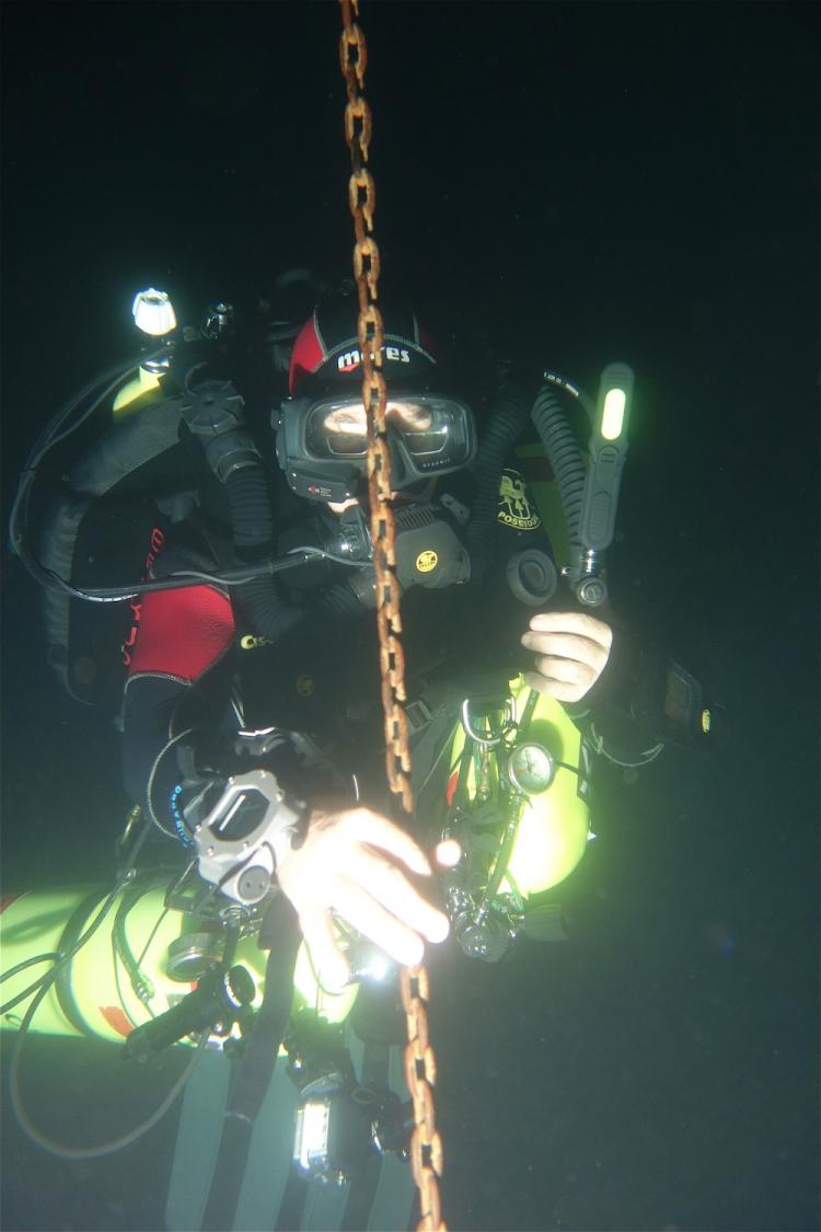
The temperature of the water was very acceptable at 20°6C. The dive time was 41 minutes, with 15 minutes along the bottom. A safety stop of three minutes at six metres was followed by a four-minute stop at three meters and a 99 percent O2 bottle was shared between Tetsuaki and myself—“To flush your excess nitrogen out!” warned Chris laughing. In fact, we came out of the water with a delightful sensation of well being.
After a three-hour interval, the afternoon dive promised to be serious stuff. Twin tanks were used this time, with a mix of 19 percent oxygen and 30 percent helium.
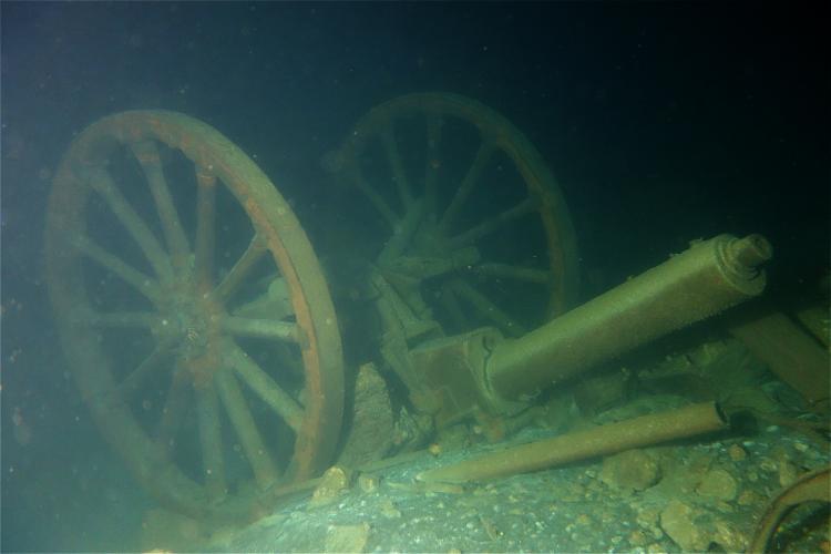
During WWI, the Deutsche Schutztruppe of the German colony was attacked by the forces of the new Union of South Africa, fomented by the British crown. The army of the Reich was pushed north as far as Tsumeb, where the Germans finally capitulated. To prevent their armaments from falling into the hands of the enemy, the German army dumped all their canons, ammunitions and guns, late June 1915 (Gunther Walbaum).
Since then, a number of these war relics have been salvaged in the 1960s and in the 1980s by intrepid recreational divers from Tsumeb. These items are on display today at the small Tsumeb Museum. It is a colourful history, which has left its mark on Namibia forever, for even today the influence the German presence had is evident in the country.
Night dive
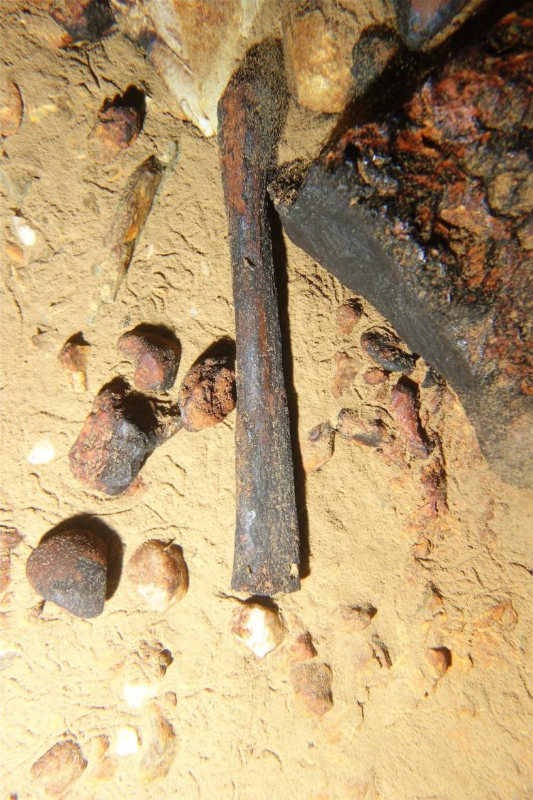
A night dive to 57m was done over a highly volatile sedimentary bottom. Resting upside down on the bottom was the so-called ‘Cannon’ and its two wooden wheels. Built by the company Friedriech Krupp in 1903, the 3.7cm automatic machine gun (POM-POM) shot projectiles of 1 pound (450grams), with a maximum range of 2,750 metres. A perfectly restored specimen can be admired at the Tsumeb Museum, as well as other pieces of artillery.
The Germans would have thrown away between 300 and 400 wagons of ammunition, 24 cannons and 85,725 Mausers. One of the wagons is now on display at the “Alte Feste” in Windhoek, the old German fort of 1890.
Suffice it to say that the stay at 57m depth was rather short, a fortiori when the visibility was soon disturbed by the presence of divers. Particles in the water was not conducive for flash photography, therefore I had to take pictures in ambient light, i.e. with a torch.
A few boxes of ammunition lay about, as well as a few live shells. The return to the surface required three deco stops at 9m, 6m and 3m, the latter two on pure oxygen. Despite it all, my Aladin computer was not satisfied with the treatment and added a 22-minute safety stop at 3m.
Steff helped me understand with his slate: “You are on oxygen, not air!” My computer was not adapted to these advanced gas mix calculations.
I came up to the surface to the great relief of Tetsu who reckoned that it was taking too long. However, my Aladin, frustrated beyond words, started beeping madly and went into SOS mode for the next 24 hours, depriving me of my computer for the next day’s dives. Tech diving is such another world.
“How about some ‘Fire Water’?” suggested Steff with a laugh, to celebrate the event. After a polite refusal, Tetsu complied and ended up tipsy, as was expected!
Guinas sinkhole
A bird’s flight away in the direction of Etosha National Park, Guinas Lake is an elliptic sinkhole at 140m by 70m. To be politically correct, we pay a visit to the new owners, Nyck and Ludye of Cando Farming, producers of onions and potatoes, a farm of 700 hectares.
“The access to the sinkhole belongs today to three different partners, each one having his own pumping station,” explained Chris. “In the old days, the best entry point was on the side of an angry farmer, who had the habit of shooting at any diver who attempted to cross his territory secretly,” lamented Steff.
Twenty years have passed, and thank heaven, the angry bird is no more! “Before independence, Guinas was a food production farm for the South African army,” added Nyck.
A striking difference to Otjikoto is the crystal clear appearance of Guinas Lake. The water has a cobalt blue colour and the visibility is optimal, an underwater photographer’s dream come true.
We drive the 4x4 to the lower end of a rocky slope, near an old pump station in a landscape of aloe and spiny shrubs.
Chris had the 15-litres tanks ready with a 26 percent oxygen mix. Since the level of the lake was much higher this year, we could access the water with a rusty staircase, missing each and every step for convenience.
Chris and Steff decided to dive with their rebreathers and gave us a free ticket to have our own dive the way we pleased.
I chose to have it counter clockwise at first. Impressive, the walls of the sinkhole dropped vertically into the abyss. From hearsay, the maximum depth—up to 120m—was still beyond human reach.
Carved into dolomite 700 million years ago, the typical karst environment of Guinas reveals the spreading of various caves underground. According to geologists, Guinas would be the 12th largest cave in the world, something to make you wonder.
An endemic species of Cichlidae fish was discovered here—Tilapia guinasana, which is about 10cm long, with colour variations from white to almond green, yellowish, brown, grey to black. The fish move about in small groups, close to the surface waters.
Diving Guinas
The entrance of a cave caught my attention at 31 metres. A slope of sediments came down to 40m into the darkness. A line extending across a passage underground told me that prior explorations had taken place there.
To my astonishment, I gazed upon a long bone lying on the cave floor—perhaps an oryx? Then I fell upon the upside down blackened skull of an old warthog. At once, I recognized the widening of the nostrils towards the end of the head (or muzzle). They were very ancient bones that I refrained to collect. A couple of photos should satisfy my curiosity.
The tunnel continued at depth, blowing away any illusions I may have had of venturing in myself. The curiosity killed the cat.
The second dive at Guinas with Tetsu was done clockwise, starting from a pipe on the north side. The cliff there was carved into a vast cavern where I observed some stalactites on the roof—proof that the cave was out of the water for some time. A proper tunnel disappeared underground at 40 metres, clearly too deep for a sensible cave diver.
To my bewilderment, from the beginning of the dive, the walls of the cavern were covered with a metallic dark silver sheen that reminded me of galena (PbS or lead sulfur). A thought sprung up in my mind that the walls had a conspicuous ‘cooked aspect’.
Recollecting my university background in geology and considering that the temperature of the water in Guinas was abnormally high at 27°C, I came to the conclusion that the sinkhole was an active hydrothermal vent, related to some ancient volcanic activity.
The magmatic process combined with the Damara orogenese 550 to 580 million years ago—a mountain building event—bringing ore deposits from a solution of hot water, the source of which remains uncertain to this day. A visit to the Geological Survey Museum in Windhoek confirmed the occurrence of galena in the region of Tsumeb, already famous for its copper mines, zinc, lead, silver, nickel and other minerals exploited by the Germans.
As the day faded to an incandescent sunset, the bush seemed on fire.
“Time for ‘Fire Water!” joked Steff, who had not lost his sense of humour. He handed a drink to Tetsu who could not refuse. “Oh no, I will be drunk again!” he moaned and laughed at the same time. We returned joyfully to Tsumeb after dark. Tonight was our farewell dinner at the Drus campsite restaurant.
Otavi
The Otavi Mountains form parallel ridges extending east to west. This mountain range is a mine of karstic treasures, and some like Ghaub Cave, have been classified as national monuments.
At 1,643m above sea level, Harasib Chasm on top of a limestone ridge is truly impressive. A vertical pit of more than a 100m, which is only accessible to highly skilled speleologists. In June 2012, Gerald Favre and his team led an exploratory mission with a technical dive to a depth of 147m underwater—still bottomless.
Not far from here, another marvel of nature is hiding in the darkness of Dragon’s Breath Hole. The dolomite karst is a reminder of the erosion of the Tsingy in Madagascar, carved like Swiss cheese, with very sharp stone needles.
Back in 1986, the cavers of the South African Speleological Association (SASA), discovered a gigantic underground lake of 19,000 sq m (i.e. 200m by 145m). Appearances are misleading for the entry hole is a chimney only one metre in diameter!
We climbed down five metres underground with a red metallic ladder. A colony of tiny horseshoe-nosed bats welcomed us under a ledge. A horizontal progression of ten metres led us to a crack and a dead end. “From here, it is a 120m vertical drop, abseiling (rappelling) to the level of the lake,” confirmed Chris with a smile.
Following the departure of Chris and Steff, our last exploration was done at Ghaub Cave, a national monument on the top of a ridge. Ghaub Guestfarm leads guided tours inside the cavern.
“We’ll have to make our way for about 100 metres underground before we get to the water,” said Andreas, the guide. Of course, we had to carry the tanks and the dive gear, with a helmet and a head lamp through a maze of narrow corridors and boulders, which we needed to climb up and down.
“It can be a bloody affair,” I was told. To make things easier, I donned a 5mm wetsuit and a 15-liter tank on my back; plus, I carried a camera and a mesh bag in my hands.
The sustained effort made me sweat profusely. I was literally overheating. My heart beat like a drum. I suddenly gasped for air and realized that I could not breathe. I felt like I was very close to having a heart attack; my survival system was on high alert with a red light blinking.
So, when our guide Andreas pointed out to the waterhole some 2.5m down an almost vertical narrow pit, I was in shock. If we ever made it down to the bottom, it would be impossible to come out of the water. We would be drowned like rats.
“We won’t make it—it’s too risky!” I puffed, as I glanced sideways to a dumbfounded Tetsu. While the water was gin clear and appealing, I decided to call it off. We turned around, to the great relief of Tetsu, who did not really feel like going for it either. A wise decision indeed.
Afterthoughts
The return to the outside world was a painful affair. The tank was heavier to carry. The fresh air of the surface brought me back to life, though. “In extremis,” I thought to myself.
This chapter in our exploration of Namibian caves and sinkholes was closed for now. Back at Ghaub Guestfarm, we recovered from our emotional adventure. A dip in the cool waters of the swimming pool and a cold beer on the lawn did the trick and brought smiles back to our faces. ■
Pierre Constant has been leading trips to Namibia for over 20 years. He will organize a dive trip there in April and October 2014. For more information, email calaolife@yahoo.com or visit www.calaolife.com.


")


")