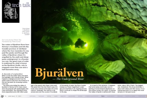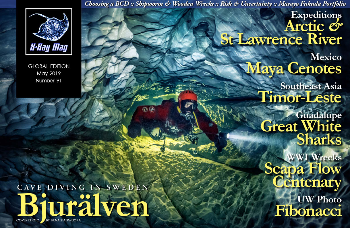
The waters of Bjurälven flows from Norway’s mountains and into the Swedish province of Jämtland where the river meanders its way past the peaks and through the valley of Bjurälv where it is engulfed by the earth and disappears underground. In a thunderous roar, the great mass of water is swallowed by what is known as the Bjurälven Grotto, only to reappear more than one and a half kilometres away.

Contributed by
What course the water takes and what the passage is like nobody knows. What happens underground and how the water make its way from the entrance to the exit has been an enduring mystery. Until now.
The area surrounding the valley of Bjurälven is famous for its many caves and very popular with speleologists and cave enthusiasts. The calcareous limestone deposited some 450 million years ago is the reason why these caves exist. The water from the river finds its way into nooks and crannies and seeps into every crevice. Gradually, the calcium is dissolved and over the course of hundreds of thousands of years, the flow of water hollows out these magnificent underground chambers in an ongoing process, which continues to shape the landscape to this day.
As a result of this dynamic, it happens that some areas eventually cave in, leaving a funnel-shaped depression on the surface known as a dolin. The valley of Bjurälv is dotted with these dolins, about 300 of them. The biggest one, Snödolinen (The Snow Dolin), is about 20m deep and 50m across. It is so named because it is so deep that snow remains in it all year round.
Discovery
In 1979, the Swedish federation of speleologists held a congregation in the valley of Bjurälven, and during this event, the attendees set out to visit the local caves. The longest cave in Sweden, Korallgrotten (The Coral Grotto) is located only a few kilometres from the valley of Bjurälv, and its passages reach more than 6km into the mountains.
One of the participants was Bo Leander, a dedicated speleologist and explorer with a vast experience in other caves. During a walk along the valley, Leander and his company happened to pause at a sandy beach by Dolinsjön (The Dolin Lake), a water-filled dolin. As he was enjoying a cup of coffee, gazing into the crystal-clear water, he caught a glimpse of what appeared to be an opening at the bottom and decided to take a closer look. It just so happened he still had his wetsuit, dive mask and Nikonos camera in his rucksack, after exploring some other cave earlier on. So, he jumped into the lake, holding a rock, and slowly descended to the bottom.
As it turned out, he was right. There, on the bottom, barely visible among the gravel, was an opening to a cave. The opening was quite small, about 10cm, and far too narrow to enter. But it was a significant find. Leander photographed the opening with his Nikonos camera. A map was drawn of the area, and the opening in the middle of the lake was marked. At that point in time, nobody had any inkling that this discovery would be of so much interest to a cave dive expedition more than 30 years later.
The challenge
In 2006, I had just arrived home from Florida with a freshly-minted cave diver certificate. An interest in exploring caves had started to manifest itself, and some of my dive buddies were up for taking a closer look inside Tuna Hästberg, an abandoned mine in the county of Dalarna. Diving in the mine was spectacular. We climbed down the shaft and camped overnight on the floor of quarry, falling asleep to the sound of water dripping from the ceiling. I loved every second of it.
This was when we began talking about the caves in Jämtland. My friends, who were far more knowledgeable on this topic, had tuned their interest to the valley of Bjurälven, which had plenty of caves to explore. Evidently, a cave was discovered under a lake during the 1970s, and some diving was conducted during the 1990s. But due to the strong current, which is often prevalent during the summers, attempts to get inside the cave were unsuccessful. Another factor was that the area was about 5km from the nearest road accessible by car, and in the middle of a nature reserve.
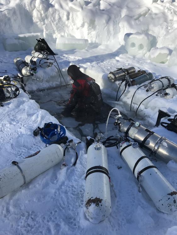
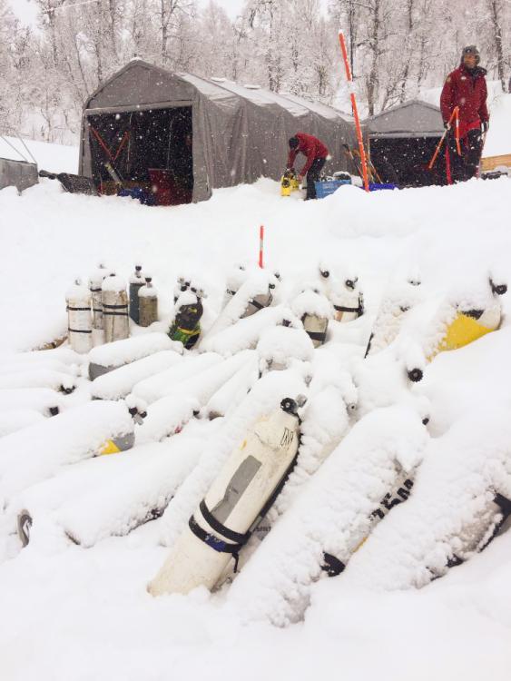
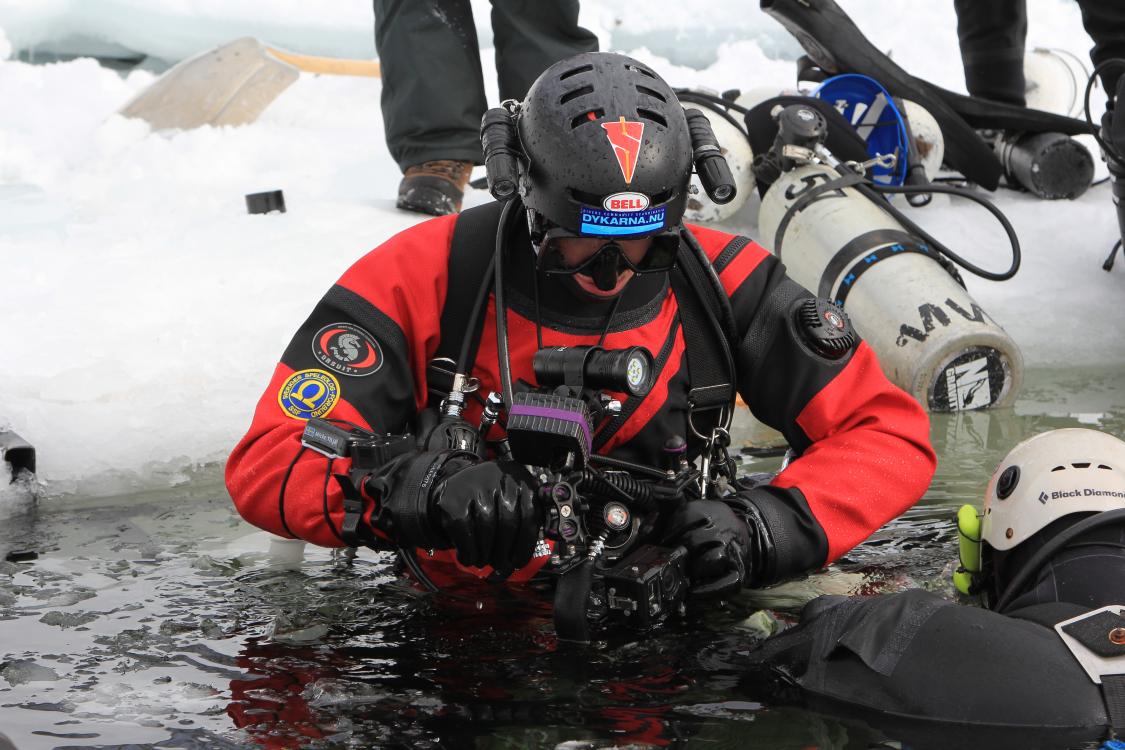
Getting all the required equipment to the location, without impacting the protected area, posed quite a challenge. We either had to carry it all in ourselves, 5km over rough terrain, or we needed to use a helicopter. Neither option was feasible, so a completely different approach was required. The dives would have to be conducted during winter.
Thanks to the federation of speleologists, we succeeded in obtaining a permit to enter the otherwise strictly-guarded nature reserve for one week, using snowmobiles. Over the course of many evenings, a select group of divers met to plan what would become Expedition Bjurälven.
First expedition
In the beginning of March 2007, we were on our way to Jämtland. The car was packed with dive gear and clothes for a week, as I set a course for our destination, Stora Blåsjön, where we found accommodations in a former school. Halfway there, my phone rang. It was the driver of the first car in our group who had left the evening before, and after suffering a mechanical breakdown, had almost made it to our destination.
The Meteorological Institute had issued a “class three warning,” which referred to extreme weather situations that can be very dangerous. The snow was coming down in droves. The other driver was now stuck, even in his four-wheel drive. So, if I carried on, I should be prepared for spending the night in the car.
I elected to turn about. Baffled, I later heard that dives had been conducted in the Bjurälv valley. Attempts to enter the dolin lake were unsuccessful, but a string of other interesting finds were made. Some 60m of a new cave had been mapped, and enthusiasm was running high. Another attempt had to be made.
Next attempt
The following year, a group of 13 keen divers gathered to make a new attempt, and once again, the dolin lake was the focal point. Half of the team would explore Festins Grotta (Festins Grotto), a passage that was explored during the 1990s when divers Carl Douglas and Johan Candert (who were featured in X-Ray Mag #36), along with speleologists Johan Utas and Leif Sigvardsson, succeeded diving into one opening of the cave and reemerging from another some 70m away.
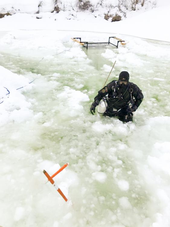
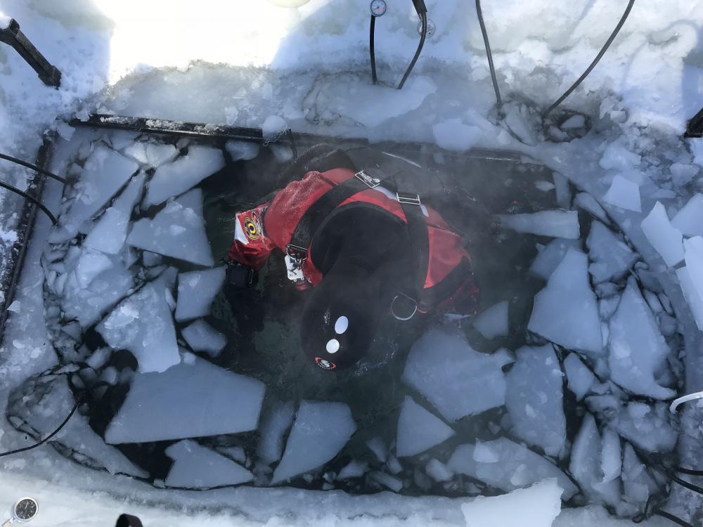
While the team I was in explored Festins Grotta and successfully followed the steps of the earlier group, the other team at Dolinsjöen (the lake) had made significant progress. After cutting through metres of ice, creating an opening big enough for divers to enter and exit the lake, they began steadily digging away the gravel blocking the view into the opening Bo Leander had found so many years prior. After some digging, one of the divers, Nicklas Myrin, lay down on the gravel and slowly backed into the hole, legs first. The soft gravel packed around his body, as he slowly inched himself into the dark unknown behind him. The light from his torch disappeared from view, and the team anxiously, and with some trepidation, awaited to see what happened. After a while, the light reemerged, and back on the surface, Myrin announced that there was a big space inside.
Uncharted territory
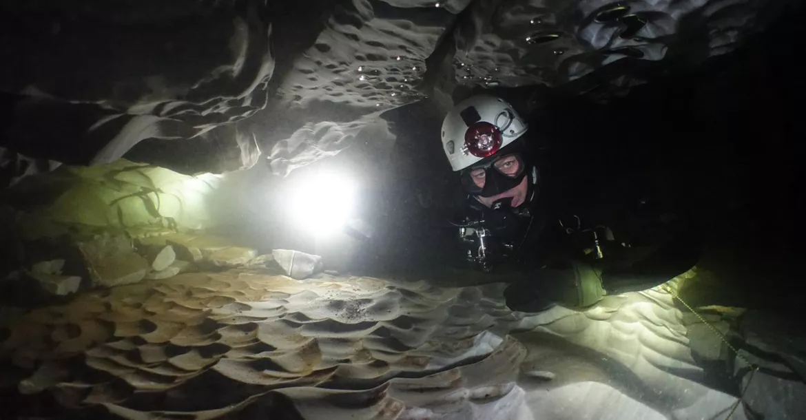
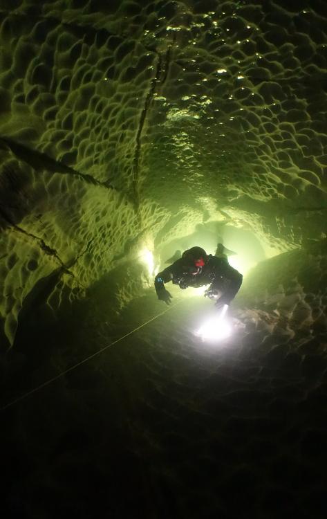
A decision was made to get right back in, and this time, three divers prepared to enter. After some more digging and further effort, all three of them made it through the narrow entrance. The water was crystal clear, as the cave was illuminated for the first time ever. We were in uncharted territory. Nobody had been here before, and it was impossible to anticipate what lay around the next corner. Some 50m inside, the divers turned around in order to ascertain whether this was the right location for a continued exploration of the river. Plans for trying out other locations were abandoned, and going forward, the dolin lake became the hub and main starting point for further exploration.
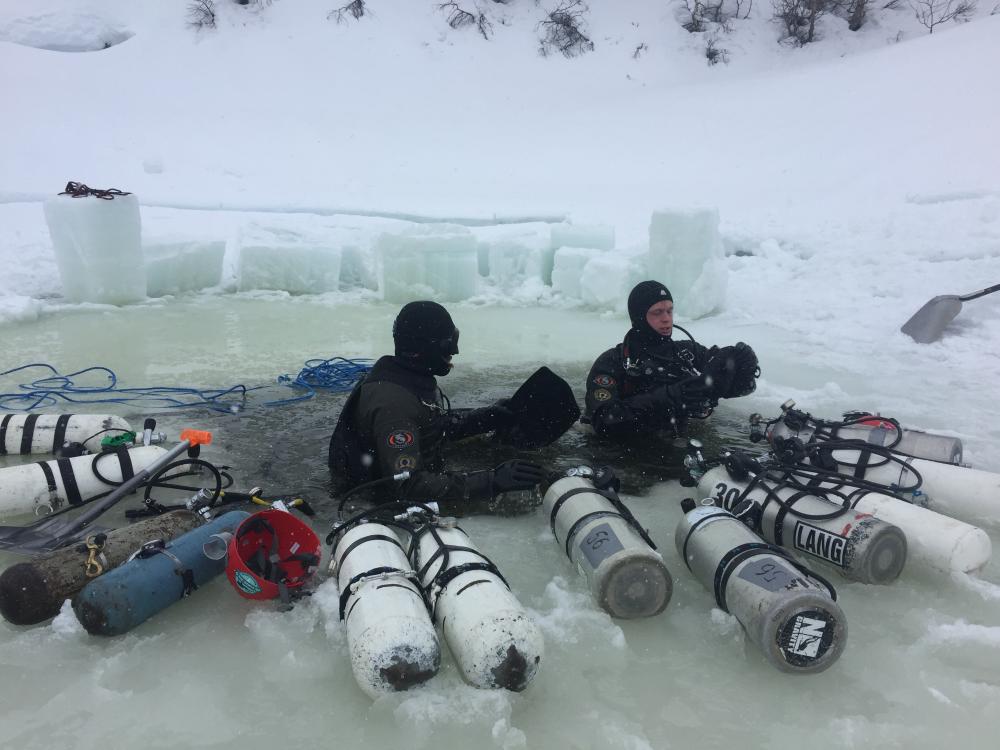
Caves must be surveyed and mapped, and in the case of Bjurälven, it was decided that 3D mapping would be used on the whole system. In cave diving, lines are used as guides for navigating the labyrinth of passages, and emphasis is placed on positioning these lines in such a way that divers are led to the exit, even in low visibility. The guideline also serves as a reference for mapping the cave. Aided by compasses, dive computers and measuring tapes, directions, heights, depths, and right and left turns are recorded. As time-consuming and laborious a manual process as it might be, it forms the basis of creating a 3D model of the explored areas of the cave. After some successful dives in the dolin lake and compilation of the collected measurements, it became evident that this was the longest underwater cave in the country.
Despite our initial successes and all the progress made, we soon came to the realisation that organisation and safety needed to be strengthened. Diving in caves in a remote mountainous region in the subarctic, beneath rocks and ice, in temperatures close to freezing, several kilometres from the nearest road and no cell phone coverage, poses some immense challenges. Even those few incidences we suffered initially, with overloaded snowmobiles keeling over and regulators that kept freezing and free-flowing, were exhausting. But in due course, we gradually found solutions and improvements were made, and the organisation was now properly set up for taking on the next challenges ahead.
Second expedition
Six years after our first expedition, we came to face a completely new scenario and new challenges. Stefan Barth and Markus Nord had swum for half an hour into the cave, making it to the farthest point so far. They were following the passage in an upward direction when they noticed something peculiar, a reflection on the water’s surface. They cautiously approached and broke the surface. As their light beams illuminated the interior, they immediately realised where they were—in a huge chamber, located nearly half a kilometre inside the mountain.
This sensational discovery was shared during the meeting that evening, and the cave was further mapped the following day. What was discovered was a 100m-long, air-filled section of the cave, with fantastic colours, shapes and contours in the different layers of limestone, and even a 5m-high gallery. From the ceiling of this big chamber, a constant flow of water rained down, creating a little waterfall, which is why this space was named Regnsalen (The Rainy Hall).
Coming up with names
Naming the different sections of cave enabled us to better discuss the various areas, and they were often named on the basis of their appearance or after some event that took place at that location. Klappa Fisken (Pet the Fish), Tempelgången (The Temple Corridor), The Crack, Snorkeln (The Snorkel), or the recently explored tunnel Don’t touch that rock! were all examples of names to which we could all relate.
The latter one, as the name indicates, described a spot where utmost caution was required. In order to proceed farther into the cave, divers had to make it through a narrow vertical shaft in the air-filled part of the cave, which was already quite a risky undertaking. But adding to the dangers was a nearly two-tonne boulder, balancing precariously just overhead. In other words, this was a rock you obviously did not want to touch.
A way forward
I had the pleasure, along with Pirre Sandberg, of naming a section myself, which we happened to stumble across. It would turn out to be the way through which all further exploration would pass.
The expedition had arrived at an impasse. Two passages were explored, but they did not seem to lead anywhere. While frustration was starting to build, as the divers farthest in were trying to find a way forward, Sandberg and I decided to take a look at a side passage. I grabbed my reel, and we went to have a look through two narrow sections.
To venture into such spaces, not knowing what lay farther ahead, is not for those prone to claustrophobia. Would it be possible to turn around inside, or would we be forced to move out backwards through a passage, which was so low that our bellies and our backs would be scraping along the rock? Despite these concerns, our excursion paid dividends. Once we were past the two narrow sections, the space opened up to a 5m-wide tunnel, which stretched farther ahead than we could see in the light of our lamps.
We attached our line to a rock and swam back out. On the surface, we were jubilant and hugged each other before yelling to the dive leader that we had found the treasure room. This expression (Guldrummet) stuck and became the permanent name for this passage, which turned out to be the way farther into the cave.
Precise mapping
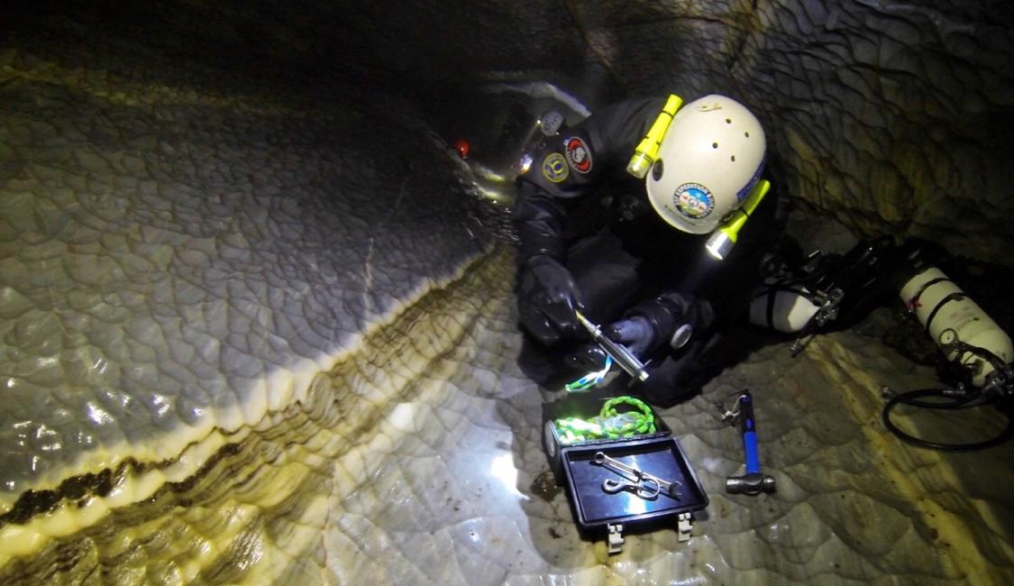
The mapping and documentation of the cave was taken to a higher level when Leander, who discovered the entrance to the cave in the 1970s, was invited to take part in the expedition. Leander is not just a cave enthusiast but also one of the country’s leading authorities on radiocommunication and homing. In consultation with the dive team, he developed a transmitter and receiver that could pinpoint a location in the cave, relative to the surface, with great precision.
In order to produce precise charts of the cave, a number of points in space had to be localised with a high degree of precision. We called such points “fix points.” Made up of small tags of stainless steel with unique ID-numbers, these fix points were attached with bolts to various strategic locations in the cave. These fix points were then traced from the surface and recorded, using a professional-grade GPS. This procedure was highly precise and enabled us to superimpose our survey of the cave onto a map and see exactly where the cave went under the landscape above.
Further discoveries and risk analysis
The discovery of Regnsalen and the air-filled sections turned out to be just a few of many more discoveries to come. A number of air-filled chambers have since been discovered, and each one poses its own challenges. Even as each of these sections had a lot to contribute to our adventure, they also posed many risks, because divers needed to make their way through the passages by climbing and crawling across rubble and slippery slopes while carrying heavy equipment.
In fact, the greatest risks we faced were not so much in the diving, but in the air-filled sections where a sprained ankle, or worse still, a broken leg would have serious consequences, since there was only one way out. Hypothermia was another significant risk we had to factor into our risk analysis. The water temperature was barely above freezing, so a leaking suit or glove could soon become life-threatening.
A great deal of importance and focus has therefore been placed on risk analysis and safety. During the latest expedition, a whole day was dedicated to training and practising rescue operations. Everyone practiced CPR and had basic training in handling trauma.
Hardware has also been continually upgraded, and emergency equipment, first aid kits and pain killers have been stowed in watertight containers, which have then been placed in the air-filled chambers in the cave. We also placed extra tanks at strategic locations in case of incidents, and we placed equipment topside for the immediate treatment of hypothermic or injured persons.
New challenges
Each new year presents new challenges, and weather plays a significant role. If there is too little snow, transport becomes more difficult, because we have to rely on snow ploughs to clear the road between our lodgings at Stora Blåsjön and Leipokvattnet, the last outpost before the road ends.
During our latest expedition, it rained heavily during the first two days. We had established a base at Dolinsjöen, with tents and compressor. The ice had been cut, and we were about to commence diving when the water level started to rise. As the hours went by, we could only watch the ice disappear under the rising water. The snowmobile path to our base became impassable, and ultimately, we were forced to retrieve our two diesel-powered compressors or risk losing them under the rising waters.
In the course of two days, the water level rose more than a metre, and we were concerned that we had to evacuate the whole camp. But then the temperatures fell below freezing, and our base, which had been turned into a soupy slurry, became firm once more, and the water level slowly started to fall again.
A higher water level was not necessarily a disadvantage. It meant less schlepping of equipment in the air-filled sections of the cave, and by the end of the week, I managed to conduct my hitherto longest dive, which took me to the end of sump 4.
Sumps are the water-filled sections between the air-filled parts. So, the first submerged section from the entrance to the first air-filled space would be sump 1. The trip forth and back took about three hours, of which about 85 minutes were dive time.
We were not only exploring Dolinsjöen but also approaching the cave from other sides such as the Bjurälv Grotto where the river disappears underground. During summer, the river becomes a roaring waterfall, which is impossible to pass; however, during winter, it is possible, but still cumbersome, to find a way in. The entrance is frozen solid and needs to be shovelled free. Behind it, one encounters metre-thick, compact ice. Once past these obstacles, one has to rappel 10m down the vertical shaft, after which the cave can be entered.
There were several difficulties associated with approaching Bjurälven from this side. Aside from the challenge of getting inside, there was also the matter of the current, which was going to push us farther into the cave. The biggest challenge, however, was clearing a passage through all the rock and other debris, clogging up the entrance. The team that last explored the Bjurälv Grotto had to clear out several tons of rubble in order to battle their way forward, one metre at a time, to make it inside, through rapidly-flowing water. The objective was to make it possible to safely conduct diving from this entry.
Sweden’s sixth longest cave
During this year’s expedition, the cave under Dolinsjöen was explored a further 110m, which takes the total known length to 2,245m. This is the sixth longest cave in the country, and only 35m shy of being the fifth longest. The satellite images showed that we had made it about halfway to the Bjurälv Grotto. From the other end, some 275m has been explored so far. Every year, we get a bit closer to the ultimate goal of tracing the flow of the river and mapping the connection between the two openings. ■